Why Neighbourhood-Scale Data Matters in Urban Heat Warnings
Updated: Aug 2
New UrbanAIR research published in PLOS Climate reveals that official county-level heat warnings missed 24 high-stress urban days in a single summer—and shows how AI-driven microclimate modelling can fix it.

The Problem: One Warning Doesn't Fit All
As climate change increases the frequency, duration, and intensity of heatwaves across Europe, cities face an escalating public health crisis. Urban heat is particularly dangerous because cities are complex 3D environments: concrete, asphalt, building heights, and a lack of green canopy trap heat and absorb solar radiation, creating severe thermal stress for pedestrians.
Despite these dramatic microclimate differences, most official Heat-Health Warning Systems (HHWS)—such as Germany’s regional and county-level system—operate at broad spatial scales, covering at the same time urban areas and their rural surroundings. A single warning covers an entire administrative district, treating a shaded, tree-lined suburban street and a densely paved downtown plaza as if they experienced identical heat conditions.
In a new paper published in PLOS Climate, UrbanAIR researchers Svenja Ludwig and Andreas Christen (University of Freiburg), along with co-author Ferdinand Briegel (Karlsruhe Institute of Technology), demonstrate that neighbourhood-scale heat stress in cities is often much higher than reflected in official warnings issued at regional or county-level, and present a hyper-local solution.
The Innovation: AI-Powered Pedestrian Heat Stress Mapping
To capture the complex thermal environment where people actually walk and gather, the research team developed high-resolution Pedestrian Heat Stress Products (PHSP).
Using an artificial neural network known as the Human Thermal Comfort Neural Network (HTC-NN), the team modelled hourly heat stress across Freiburg for the summer of 2023 at an unprecedented 1 × 1-meter spatial resolution.
Freiburg im Breisgau, Germany, served as the study area for testing the neighbourhood-scale heat warning model. Source: Envato elements
How the framework works:
True Physiological Impact: Instead of relying solely on-air temperature, the model calculates the Universal Thermal Climate Index (UTCI). UTCI accounts for air temperature, humidity, wind speed, and mean radiant temperature—the crucial shortwave and longwave radiation absorbed by the human body in sunlit versus shaded spaces.
Neighbourhood Aggregation: High-resolution 1-meter predictions were aggregated to a 512 × 512-meter neighbourhood scale while specifically excluding building footprints to isolate pedestrian-level exposure.
Tiered Heat Stress Levels:
Level 1 (Strong Heat Stress): 2 or more hours per day exceeding 32°C UTCI.
Level 2 (Very Strong Heat Stress): 30 or more minutes per day exceeding 38°C UTCI.
Key Findings: What Regional Systems Miss
When the team compared their neighbourhood-scale PHSP output against official county warnings and local weather station networks, the results were striking:
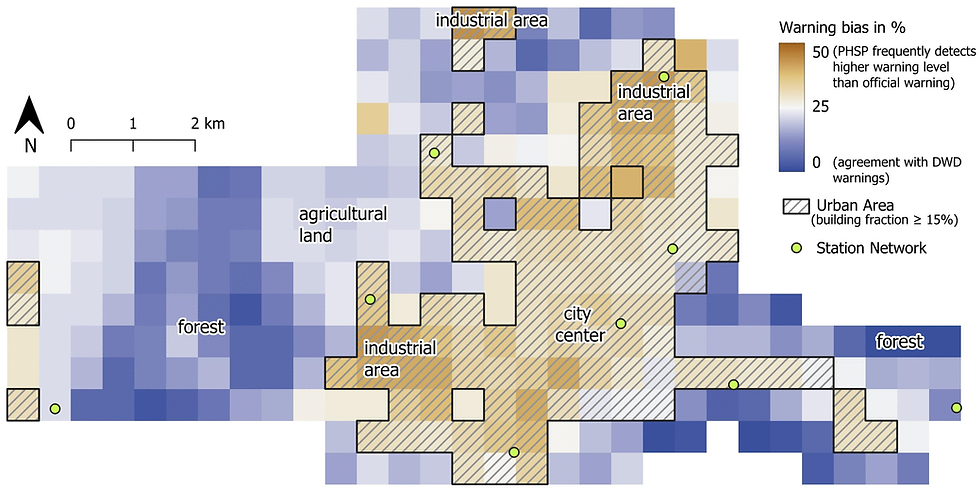
24 Missed Urban Warning Days: In the summer of 2023 alone, the official county-level warning system failed to issue warnings for 24 days where urban neighbourhoods experienced severe pedestrian heat stress.
Urban Amplification: Urban areas experienced 1.2 times more Level 1 heat stress days and 1.8 times more Level 2 (very strong) heat stress days compared to surrounding rural areas.
Extreme Heterogeneity: Heat stress levels varied drastically within the same city based on building geometry, surface materials, and tree coverage, showing that vulnerability changes from block to block.
High Model Accuracy: The machine learning predictions agreed with urban weather station data with 82.0% accuracy, demonstrating that AI can reliably simulate microscale thermal comfort across an entire city.
Why This Matters for UrbanAIR and Future Cities
To protect public health during extreme heat, municipal leaders, healthcare providers, and citizens need actionable, location-specific information.
By proving that neural-network-driven models can rapidly generate accurate, neighbourhood-scale heat stress indicators, this study provides a blueprint for the next generation of urban heat health warning systems. Instead of issuing blanket warnings, future systems can help cities pinpoint vulnerable neighbourhoods, deploy emergency cooling centres where they are needed most, and design targeted urban greening strategies.
Transitioning from coarse county-level warnings to high-resolution, neighbourhood-scale monitoring delivers actionable heat risk information right down to where citizens live and walk.
Read the Full Paper & Access Data
Paper Title: Evaluating the potential for heat warning systems to account for intra-urban variability
Authors: Svenja Ludwig, Ferdinand Briegel, Andreas Christen
Journal: PLOS Climate (2026)
Open Data & Code: Underlying PHSP datasets and the HTC-NN model code are openly accessible on Zenodo.
Follow our #UAYoungResearchers Campaign
Learn more about the digital tools our early-career researchers like Zvenja Ludwig are building that city planners will use to create healthier, safer, and more resilient urban environments.
This work was supported by the European Union’s Horizon Europe research and innovation program under the UrbanAIR project (Grant No. 101188131).


Comments