From Idea to Impact: The Green Potential Map User Journey in UrbanAIR
- May 27, 2025
- 4 min read
Updated: Jan 19
Co-Creating Urban Climate Services That Are Useful, Usable, and Used
In UrbanAIR, we aim to co-develop urban climate services that are useful, usable, and ultimately used. The Green Potential Map is a perfect example of how early stakeholder engagement, technical innovation, and iterative development can lead to a meaningful tool that supports cities in their climate adaptation efforts. This is the story of how the idea emerged, evolved, and continues to grow together with the City of Antwerp.
Why Antwerp is the ideal pilot city
Antwerp was identified as a key pilot city from the proposal stage, and with good reason: the city is highly active in climate change mitigation and has access to extensive urban and environmental datasets.
Over the years, Antwerp has also developed a strong track record in science-based policymaking and has frequently collaborated with our partners VITO. These factors combined made it an ideal context to explore and demonstrate what UrbanAir could offer in practice.
Stakeholder dialogue sparks innovation
During the first stakeholder meeting between VITO and the City of Antwerp, the broader ambitions of UrbanAir were introduced by VITO, while Antwerp presented its own specific needs tied to air quality improvement, heat stress mitigation, and ensuring wind comfort.
The discussion naturally evolved into a brainstorming session, where both parties began identifying overlapping goals and ambitions. From this collaborative exchange, an idea emerged organically:
Could we map the potential for additional greening in Antwerp in a way that responds to multiple climate and health goals?
From the "Tree Map" to the "Green Potential Map"
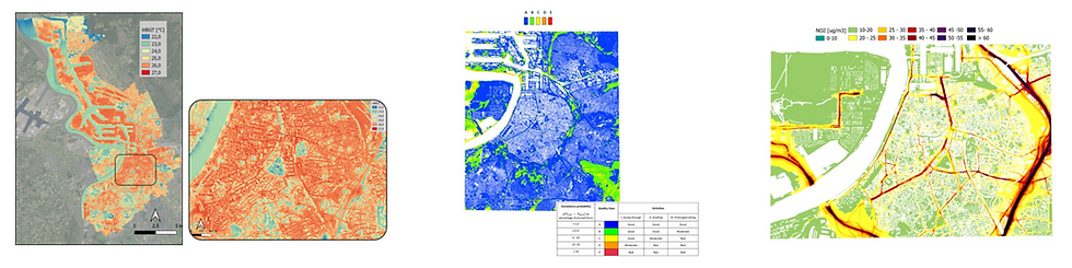
The concept was rooted in previous work by VITO, which involved using physical models to identify areas in the city most suitable for new tree planting. These early prototypes combined detailed simulations of air quality, heat stress, and wind comfort.
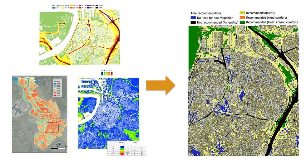
Antwerp, meanwhile, expressed an interest in updating and expanding these maps to support current planning needs. As the discussion evolved, so did the idea. What started as a "Tree Potential Map" gradually transformed into the broader and more impactful "Green Potential Map".

A multi-layered tool emerges
This transition gained further momentum during the UrbanAIR technical consortium meeting in Delft in May 2025. There, it became clear that the map could be much more than just a planning layer based on environmental modelling.
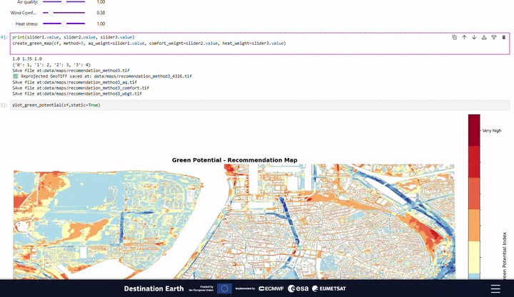
By incorporating other dimensions, the "Green Potential Map" began to grow into a truly multi-layered decision-support tool, enabling cities to take a more comprehensive approach to urban greening.

Adding social Insights with behavioural modelling
The most significant evolution of the concept came with the decision to expand the Green Potential Map beyond just physical criteria.
To understand where green infrastructure could be most impactful, we began integrating behavioural modelling, aiming to capture how people interact with green spaces in the city.

This added a crucial social dimension to a previously environmental model, making it more responsive to real-world urban life.
Interpretation and uncertainty to support real decisions
Another key addition was the development of decision-support features. These are designed to help policymakers interpret the model outputs and translate them into practical action, such as identifying greening priorities or selecting sites for new interventions.
We also started exploring how to address uncertainty in the models, an important step in building credibility and trust in the results.
The Green Potential Map: A structured user journey
As it stands today, the "Green Potential Map" reflects a structured user journey. It begins with concrete stakeholder needs, then evolves through conceptual design and technical development, before being refined and validated through ongoing collaboration.
When we place Antwerp’s ambitions side by side with UrbanAir’s evolving offer, the alignment is striking. The city’s interest in combining climate, health, and planning considerations is well supported by the integrated approach of the "Green Potential Map".
While the tool is still under development, the foundations are solid. We are not just building something technically impressive but something that will be genuinely useful in practice.
What comes next in the Green Potential Map?
Several concrete steps lie ahead in this development journey:
VITO will provide Antwerp with an updated status report on the current state of the Green Potential Map.
KNMI is working on delivering the high-resolution data required for UrbClim and OpenFOAM simulations.
Discussions are ongoing between Imperial College London and VITO about how models like PALM and u-DALES might be integrated into the process.
In parallel, VITO and Delft University of Technology (TU Delft) are continuing bilateral discussions focused on behavioural modelling and decision-support integration.
Conclusion
What makes this journey so compelling is that it began as a conversation. The idea for the Green Potential Map was not a pre-baked product handed down to users. It was proposed by the City of Antwerp during an early stakeholder meeting and further shaped through dialogue and exchange.
This is co-creation in the truest sense: an idea sparked by local needs, enriched by scientific thinking, and developed collaboratively.
As the Green Potential Map develops, it keeps that spirit alive. It's not just a model, but a shared effort shaped with cities, for cities aiming to be greener, healthier, and more resilient.
Learn more about UrbanAIR’s approach
See how we combine climate science, behavioural modelling, and co-design with cities across Europe.


Comments